19 December 1775: James Cook names a freezing south Pacific promontory after his native cathedral
James Cook. 1777. A Voyage Towards the South Pole, and Round the World, 2nd Ed., Vol. 2/2. London: W. Strahan. Get it:
.Unedited excerpt
If an excerpt is used in the book, it will be shorter, edited and, where applicable, translated.
At two o’clock in the morning of the 19th, having made sail, we steered S.E. by E. along the coast, and soon passed the S.E. point of the bay of St. Barbara, which I called Cape Desolation, because near it commenced the most desolate and barren country I ever saw… It seems entirely composed of rocky mountains without the least appearance of vegetation. These mountains terminate in horrible precipices whose craggy summits spire up to a vast height, so that hardly anything in nature can appear with a more barren and savage aspect, than the whole of this country. The inland mountains were covered with snow, but those on the sea coast were not. We judged the former to belong to the main of Tierra del Fuego, and the latter to be islands so ranged as apparently to form a coast.
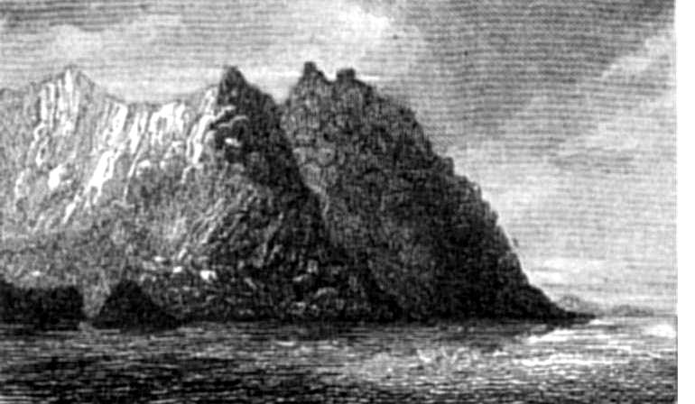
After three hours calm, we got a breeze at S.E. by E., and after having made a short trip to south, stood in for the land, the most advanced point of which, that we had in sight, bore east, distant ten leagues. This is a lofty promontory, lying E.S.E., 19 leagues from Gilbert Isle, and situated in latitude 55°26′ south, longitude 70°25′ west. Viewed from the situation we now were in, it terminated in two high towers, and, within them, a hill shaped like a sugar loaf. This wild rock therefore obtained the name of York Minster.
Comment
Comment
York Minster seems to have been at the southernmost point of Isla Waterman/Waterman Island. Darwin visited in 1830:
Weighed, warped to windward, and made sail out of Adventure Passage. I was very anxious to reach Christmas Sound, because it seemed to me a good situation for the Beagle, while the boats could go east and west of her, and the new boat might be built. Running along the land, before a fresh breeze, we soon saw York Minster, and in the evening entered Christmas Sound, and anchored in the very spot where the Adventure lay when Cook was here. His sketch of the sound, and description of York Minster, are very good, and quite enough to guide a ship to the anchoring place. I fancied that the high part of the Minster must have crumbled away since he saw it, as it no longer resembled “two towers,” but had a ragged, notched summit, when seen from the westward.
(King 1839)
Something to say? Get in touch
Similar
 12 April 0627: In a triumph for his Kentish wife, Edwin of Northumbria is baptised on Easter Sunday by Paulinus, in the latter’s wooden oratory on the site of York Minster
 22 September 1465: A menu for the enthronement at Cawood Castle of George Neville as Archbishop of York
 19 August 1931: Lawrence Ennis of Dorman, Long & Co. of Middlesbrough, producer of steel and bridges, supervises closure of the arch on Sydney Harbour Bridge
Comment
Comment
Comparison with the piece from The Spectator on the same day suggests to me that their critic is referred to above:
The Leeds Musical Festival terminated with The Messiah on the morning of Saturday last. In the performance of the solo parts there was nothing remarkable, the principal singers being the usual metropolitan celebrities, Madame Clara Novello, Miss Dolby, Mr. Sims Reeves, and Mr. Weiss; but the choruses were sung in a manner which the metropolis certainly has never been able to equal. We have already had occasion to notice the superiority of the choristers of Birmingham to those of Exeter Hall, notwithstanding their inferiority in numerical strength: at Leeds the same observation held good in a still more remarkable degree. At Exeter Hall the choral and instrumental band numbers above 700; at Birmingham it numbered about 500; at Leeds under 350: while the real power of these tuneful hosts was in the inverse ratio of their numbers. The Birmingham 500 excelled the London 700, while the Leeds 350 excelled both the one and the other. The Yorkshire choristers are the best in England, if not the best in the world; and all the Leeds choristers were Yorkshire people belonging to the working classes, drawn from the towns and villages of that musical land. Among them there was not one useless individual: they all had sound, mellow, English voices; they all thoroughly knew their parts, and consequently sang without hesitation or wavering, and their united voices formed a volume of pure musical sound which we have never heard equalled elsewhere by twice their number. Of all the districts of England the great county of York is the best able to furnish the materials for a great music-meeting; and in former times it was in the city of York that the greatest of the English Festivals was held, though it has been long since crushed by the interference of clerical bigotry. We are glad that a new Yorkshire Festival has been established. Like that of Birmingham, it is independent of the abused power of ecclesiastical dignitaries: and as the people of Leeds have emulated those of Birmingham in spirit and energy, their Festival has a fair prospect of rivalling the other in durability and magnitude. And this prospect is all the greater for the design, (which we understand, is contemplated) of rendering the Leeds Festival, like that of Birmingham, a permanent establishment, with triennial meetings for one charitable object, the benefit of the General Infirmary, a charity of great and extensive usefulness.
The financial result of this first Music Meeting at Leeds has been highly favorable. The audiences at the seven morning and evening performances amounted on an average to 2000 persons at each; the whole amount received has been about 75001, while the expenditure is estimated at 6000l: so that the charity will be benefited to the extent of about 1500l.
The appointment of Professor Sterndale Bennett (who, in addition to his high talents and reputation, is a Yorkshireman born) to the office of conductor, gave general satisfaction from the outset, and the vigour and ability with which he performed his duties, enhanced greatly the excellence of the performances and the success of the Festival.
(Spectator 1858/09/18)
George Bernard Shaw, however:
Down to 1877 the majority of the committee never got beyond the primitive notion that a great musical event was one at which Tietjens sang and Costa conducted. It was not until she died and he repudiated the committee that Leeds at last found out that familiarity with The Messiah, Elijah and the overture to William Tell, was not the climax of nineteenth-century musical culture.
Can someone point me to something about the York festival?
Something to say? Get in touch
Search
Donate
Music & books
Place-People-Play: Childcare (and the Kazookestra) on the Headingley/Weetwood borders next to Meanwood Park.
Music from and about Yorkshire by Leeds's Singing Organ-Grinder.


 Bluesky
 Extwitter